Polesia, satellite view: innovative technologies for studying the landscape
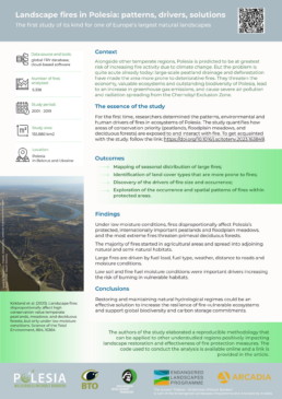
Conducting comprehensive research of a vast and varied landscape like Polesia is always a challenge. Fortunately, scientists nowadays have alternative methods that can reduce labour and time taken for field studies and make the experts’ work more efficient. For instance, the application of satellite data has made it possible to build the first landcover map for the whole of Polesia, facilitating mapping and analysis of large-scale fires that occurred in the region over the past 19 years. What are the pitfalls of working with satellite data? What should be considered when building similar maps for other regions? Let’s give the floor to one of the authors of these two studies – Dr. Adham Ashton-Butt, Senior Research Ecologist at the British Trust for Ornithology.
— Open-source satellite data can be extremely useful in obtaining environmental data over large areas and frequent measures over time. This is data that would often be too expensive or time-consuming to collect on the ground. There are limitations, however, as it is not always easy to see how data from satellites (spectral data) relates to “real” measurements on the ground e.g. moisture levels, growth of plants, soil carbon, or land cover. These relationships need to be estimated, which if not done well can result in large amounts of error.
— Your recent study analyzing the patterns of landscape fires in Polesia combines both conventional field surveys and innovative approaches that require special knowledge and skills to systematize and analyse large amounts of data. What specialists did you have to involve in your team to achieve the desired result?
— We had specialists who analyse fire relationships from satellite data, classify and utilise satellite data, and conduct statistical analysis and modeling of large data sets. Collaboration of people with special knowledge in different disciplines is very important for producing good and well-rounded research.
— Is it an easy task to “translate” the conclusions of data scientists into the language of environmental science?
— It was quite easy. In fact, environmental science and data science are very intertwined, so we understood each other very well.
— This study is the first one of its kind for the Polesia region. Did you face any difficulties along the way due to the specifics of the landscape itself or data related to it? What solutions helped you to overcome such difficulties?
— One of the biggest challenges was getting an accurate land cover map for Polesia. Existing regional maps only covered small areas, often not digitised and sometimes costly to access. Large free land cover maps (European or global maps, processed through machine learning) were inaccurate, or didn’t include important land cover types in Polesia like bogs and mires. We overcame this by building our own land cover map, by using ground-truthed data from our colleagues and then our own machine learning algorithms to process satellite data.
— Did you use a large amount of the necessary data from the ground for this research? How would you estimate the accuracy of the final results and are you satisfied with it?
— As for the amount of ground-truthed data, we used over 2000 polygons of manually verified training data. The accuracy of the land cover map was about 80%. We tested this by holding back a percentage of the training data and then checking this with the classified map. It’s always nice to increase accuracy, but overall we were satisfied with this.
— How can the methodology of this study be applied to other regions or landscapes? In this case, what basic principles will remain the same, and what aspects of the study will have to be changed and adapted?
— The fire database is global so this data can be extracted anywhere. The big limitations are the land cover maps that cover a region, these are often readily available in Europe or North America, but less so in other continents and regions.
— Are there any general recommendations for collecting preliminary data from the ground and creating a land cover map? What parameters and characteristics of a landscape, in addition to the space distribution of different land cover types, should be taken into account in order to most accurately identify the patterns of landscape fires?
— Training data evenly distributed across the region of interest is needed, as there can be spatial patterns of landcover types. For example, areas close together are more likely to be similar due to climate, geology, etc. Climate features (temperature, wind, precipitation) and topography are just some natural factors that are very important in identifying fire patterns. Human factors, such as settlements, land use intensity and land management (grazing intensity, farming practices, wetland drainage) should be certainly taken into account.
— Looking back, is there anything in your work that you wish you had done differently?
— It would have been great to have the outcome of building the land cover map of the project area as a priority at the start of the ELP project. This way we would have had more training data earlier in the process.
— What do you see as the prospects for the further application of this research?
— There are still many questions to answer. Do restored wetlands actually burn less? How long does it take them to get wet enough? How does this interact with the effects of climate change? It would be great to test our hypotheses on real restoration events.
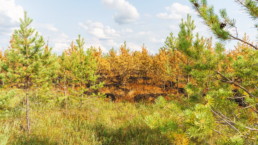
The top image features an area in Almany Mires damaged by fire in 2018. Aerial photo by Ivan Murauyou.